Resilient Settlement
Future City of Hybridity
Instructor: Alexander Wall
Research Project*
Year: 2017 Summer - 2018 Summer
Location: Portsmouth, VA
* All graphics here are individual work
This project is part of Alex Wall’s research project in the University of Virginia, which frames long term redevelopment strategies for Virginia’s coastal community.
We specifically focuses on the city of Portsmouth as a conceptual test bed for the broader circumstances of climate change and sea level rise in coastal Virginia.
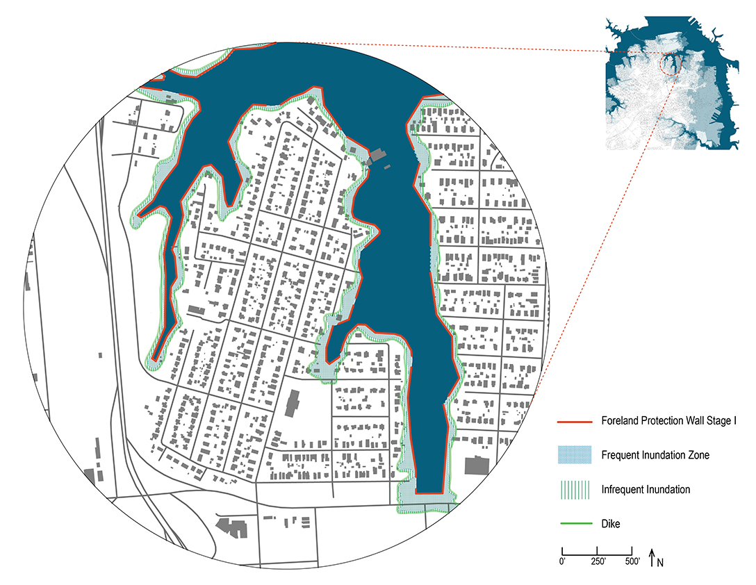
An updated understanding of flooding is required for the future development of this project. To illustrate the urgency of future sea level rise, this project shifted emphasis to temporary flooding due to storm surge, and treated current storm surge as a model for future scenarios. The project developed a mixture of defensive strategies, such as raising roads and reinforcing selective coast lines, and adaptation and relocation strategies. The project imagined a future of changed economy and lifestyles, as well as a community-lead relocation decision making process.
![]()
![]()
![]()
![]()
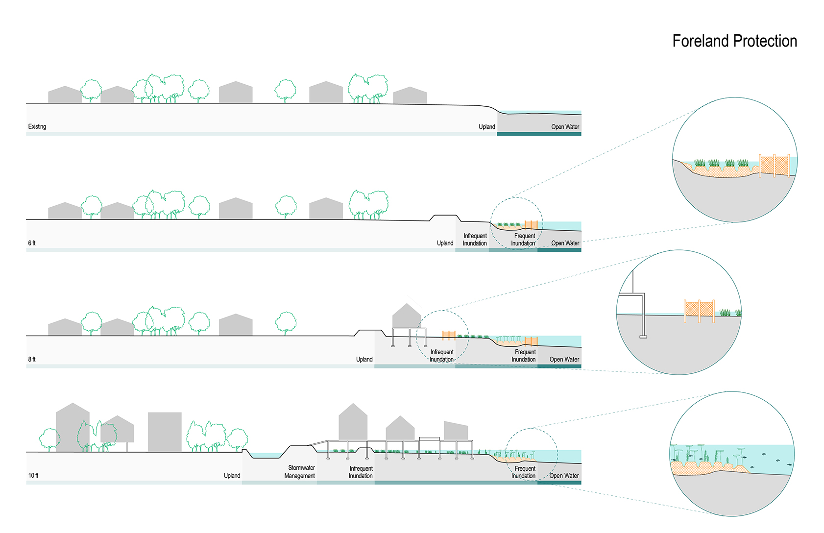
Foreland Protection: Protect against erosion and enhance sedimentation. Reduce energy of waves, break waves in shallow area, enhance safety in case of dike breaching
- 6 ft: the permeable groyne and drainage furrows were constructed. The groyne is used to break the waves and protect the inland area, and the drainage furrows are used to consolidate the mud flats. A salt marsh began to form. (groyne: permeable fence made of wood piles)
- 8ft: after the first layer of defense is breached, a new series of permeable groyne and drainage furrows are constructed behind the old ones. The salt marsh formed under 6ft water become a complicated and stable ecosystem, and new mud flats is being consolidated by the new defense.
- 10ft: both groynes submerge and deteriorate under water, the area became a stable habitat for a variety of plants and animals.
![]()
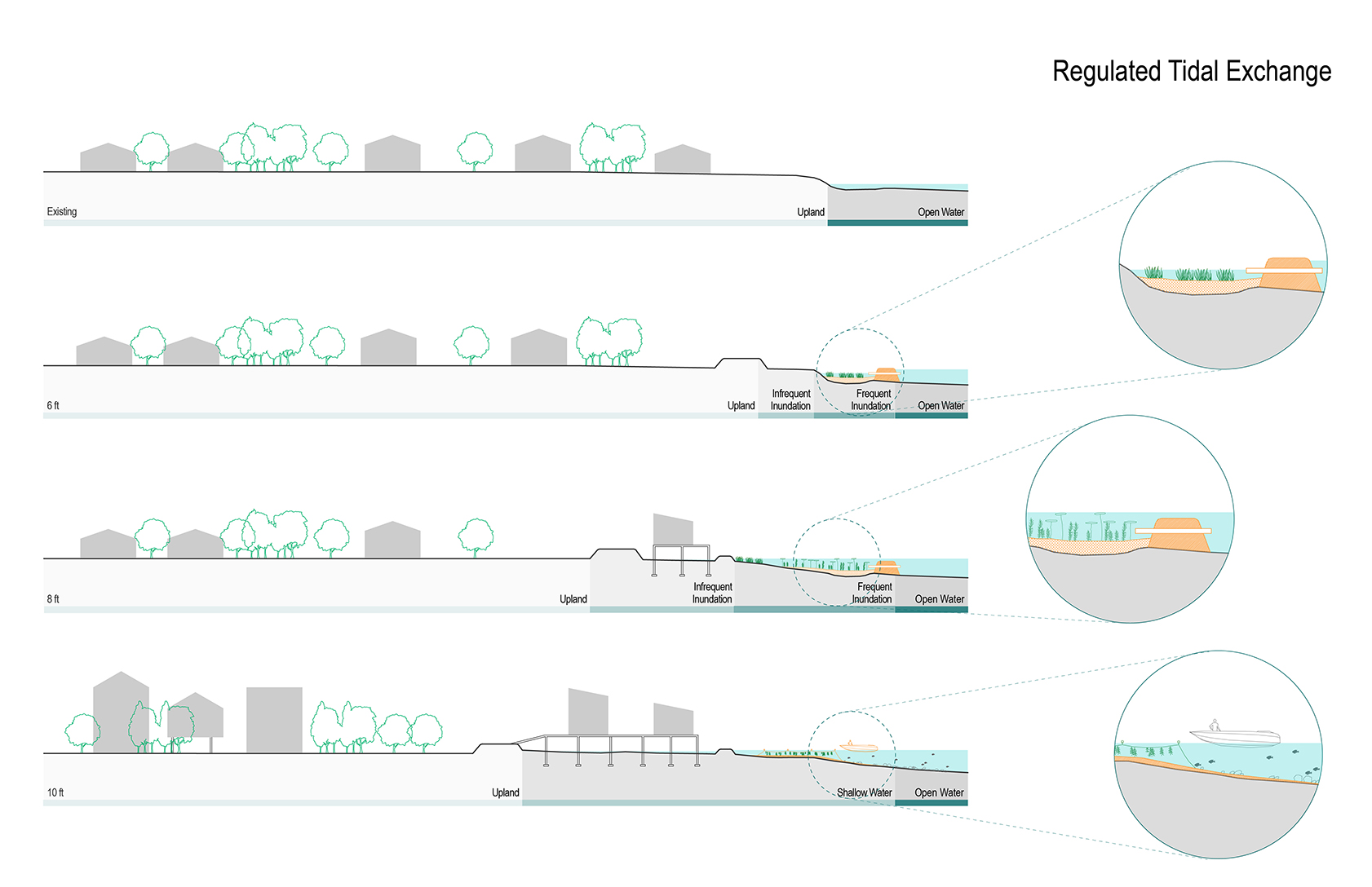
Regulated Tidal Exchange: use pipes or tide gates through existing tidal defenses to allow seawater into the land in a controlled manner. It creates brackish condition behind the defense, and gradually converting the area into saltmarsh.
- 6 ft: first series of sea walls with culverts allows sea water to flow inward, and gradually change the habitat behind the sea wall
- 8 ft: after the first sea walls are breached, new defense walls are constructed. The area became a stable habitat for algae such as kelp and other water plants.
- 10 ft: sea walls deteriorate under water, and the ecosystem becomes more and more complicated. The area could be used for recreational purpose such as bird watching and fishing, and production land for fish, shellfish, and saline tolerant crops.
Research Project*
Year: 2017 Summer - 2018 Summer
Location: Portsmouth, VA
* All graphics here are individual work
This project is part of Alex Wall’s research project in the University of Virginia, which frames long term redevelopment strategies for Virginia’s coastal community.
We specifically focuses on the city of Portsmouth as a conceptual test bed for the broader circumstances of climate change and sea level rise in coastal Virginia.
An updated understanding of flooding is required for the future development of this project. To illustrate the urgency of future sea level rise, this project shifted emphasis to temporary flooding due to storm surge, and treated current storm surge as a model for future scenarios. The project developed a mixture of defensive strategies, such as raising roads and reinforcing selective coast lines, and adaptation and relocation strategies. The project imagined a future of changed economy and lifestyles, as well as a community-lead relocation decision making process.

Foreland Protection: Protect against erosion and enhance sedimentation. Reduce energy of waves, break waves in shallow area, enhance safety in case of dike breaching
- 6 ft: the permeable groyne and drainage furrows were constructed. The groyne is used to break the waves and protect the inland area, and the drainage furrows are used to consolidate the mud flats. A salt marsh began to form. (groyne: permeable fence made of wood piles)
- 8ft: after the first layer of defense is breached, a new series of permeable groyne and drainage furrows are constructed behind the old ones. The salt marsh formed under 6ft water become a complicated and stable ecosystem, and new mud flats is being consolidated by the new defense.
- 10ft: both groynes submerge and deteriorate under water, the area became a stable habitat for a variety of plants and animals.
Regulated Tidal Exchange: use pipes or tide gates through existing tidal defenses to allow seawater into the land in a controlled manner. It creates brackish condition behind the defense, and gradually converting the area into saltmarsh.
- 6 ft: first series of sea walls with culverts allows sea water to flow inward, and gradually change the habitat behind the sea wall
- 8 ft: after the first sea walls are breached, new defense walls are constructed. The area became a stable habitat for algae such as kelp and other water plants.
- 10 ft: sea walls deteriorate under water, and the ecosystem becomes more and more complicated. The area could be used for recreational purpose such as bird watching and fishing, and production land for fish, shellfish, and saline tolerant crops.

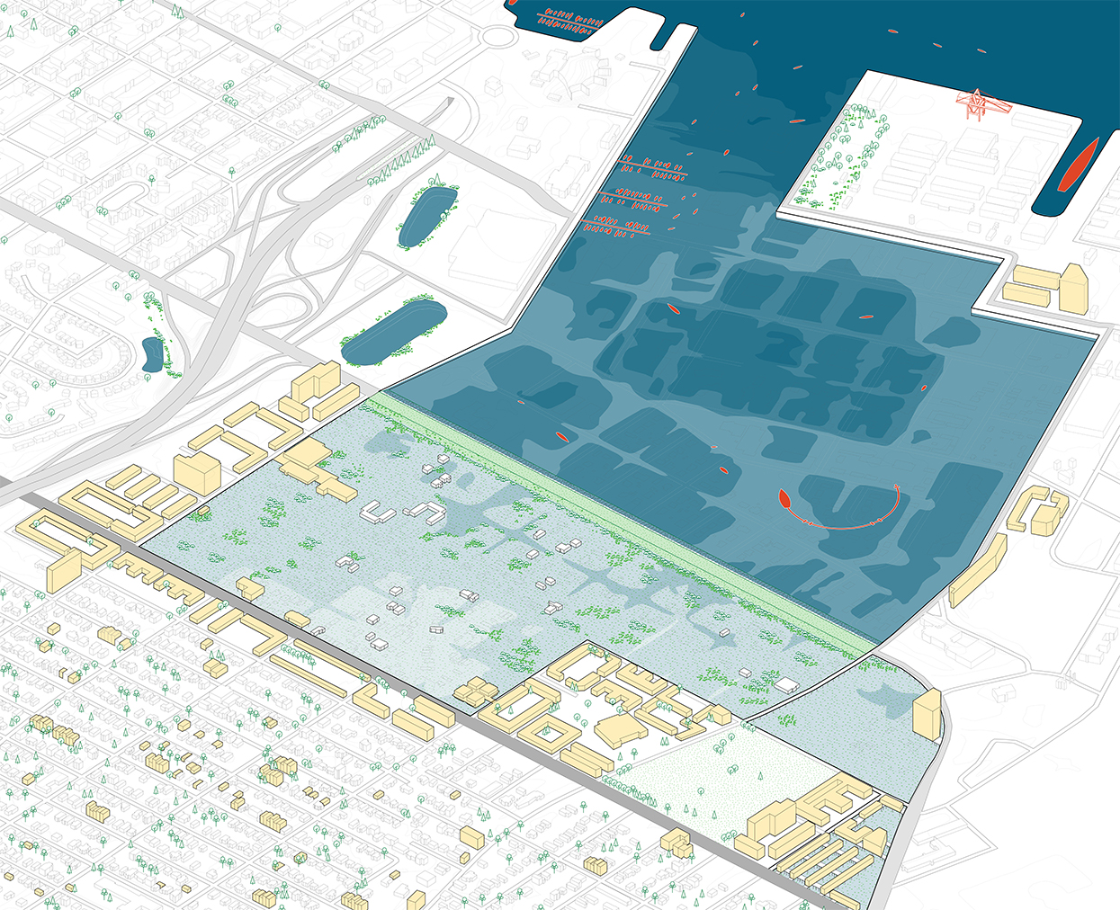
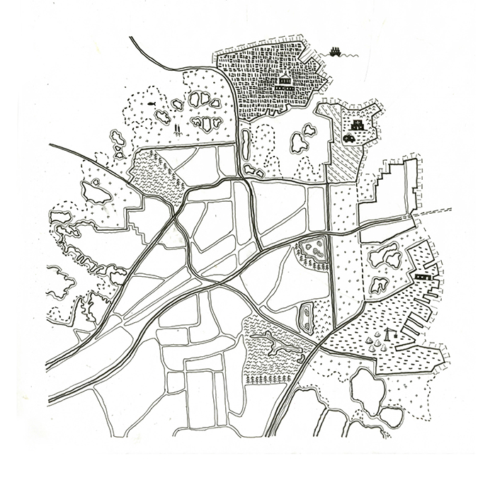
This drawing shows an abstraction of the first adaptation stage, including raised roads, emerging novel ecologies, and the beginning of urban fragmentation.
This drawing is the second stage of urban adaptation to encroaching water level. It shows the possibility of urban archipelago connected by infrastructures.