Shared Surfaces
Multi-layered Urban Strategy
Instructor: Robin Dripps
Teamwork with Ziqing Ye
Year: 2018 Fall
Location: Mumbai, India
* This project was one of twelve finalist entries in the Global Schinder Awards. It was awarded $5000 and a travel grant to visite Mumbai, India.
If you are interested in the assets we used in this project, here you can download them for free!
Cities are constituted through dense networks of interwoven, socio-ecological processes that are simultaneously human, physical, discursive, cultural, material, and organic.
![]()
![]()
Our proposal is a growing system of shared surfaces serving the different needs of the movement of water and people. Through different configuration and scale of these surfaces, the space they form is a collective effort. It would be a hybrid public space in which human and possibly other creatures co-evolve.
![]()
![]()
Teamwork with Ziqing Ye
Year: 2018 Fall
Location: Mumbai, India
* This project was one of twelve finalist entries in the Global Schinder Awards. It was awarded $5000 and a travel grant to visite Mumbai, India.
If you are interested in the assets we used in this project, here you can download them for free!
Cities are constituted through dense networks of interwoven, socio-ecological processes that are simultaneously human, physical, discursive, cultural, material, and organic.
Erik Swyngedouw Metabolic Urbanization

Our proposal is a growing system of shared surfaces serving the different needs of the movement of water and people. Through different configuration and scale of these surfaces, the space they form is a collective effort. It would be a hybrid public space in which human and possibly other creatures co-evolve.


Opportunities of a Growing City
Currently, Mumbai is a growing city which faces difficulties at multiple front - lack of housing, insufficient public transportation, demand of public spaces, etc. However, these are also opportunities for the city to evolve into a more affordable, sustainable, and inclusive place.
Our goal for this project is to create urban space which function in a socially and environmentally just way and have the flexibility to adapt to future changes.
![]() Mobility
Mobility
High number of people in Mumbai are daily commuters, and their main method of transportation is the train. The high demand of public transportation encourages new mode of movement which has high capacities such as trams and light rails. In addition to new public transportation system, there are also a considerable amount of population walk to commute daily. The large number indicates the potential for Mumbai to be a more pedestrian-friendly city.
Climate
Though the annual precipitation amount in Mumbai is high, it concentrates in only 3 month of the year and the excessive water can cause flooding. The amount of water is a huge opportunity to resolve the water shortage problems in the city. If collected, the rain water can sustain almost one third of the city.
Currently, Mumbai is a growing city which faces difficulties at multiple front - lack of housing, insufficient public transportation, demand of public spaces, etc. However, these are also opportunities for the city to evolve into a more affordable, sustainable, and inclusive place.
Our goal for this project is to create urban space which function in a socially and environmentally just way and have the flexibility to adapt to future changes.
 Mobility
High number of people in Mumbai are daily commuters, and their main method of transportation is the train. The high demand of public transportation encourages new mode of movement which has high capacities such as trams and light rails. In addition to new public transportation system, there are also a considerable amount of population walk to commute daily. The large number indicates the potential for Mumbai to be a more pedestrian-friendly city.
Climate
Though the annual precipitation amount in Mumbai is high, it concentrates in only 3 month of the year and the excessive water can cause flooding. The amount of water is a huge opportunity to resolve the water shortage problems in the city. If collected, the rain water can sustain almost one third of the city.
Mumbai Timeline
Studying the historic housing typology of Mumbai has given us new perspective of the city. Despite the amount of population, sharing spaces and resources is an important tradition in India. In our proposal, we would like to reintroduce the idea of sharing given Mumbai’s limited space.
Studying the historic housing typology of Mumbai has given us new perspective of the city. Despite the amount of population, sharing spaces and resources is an important tradition in India. In our proposal, we would like to reintroduce the idea of sharing given Mumbai’s limited space.

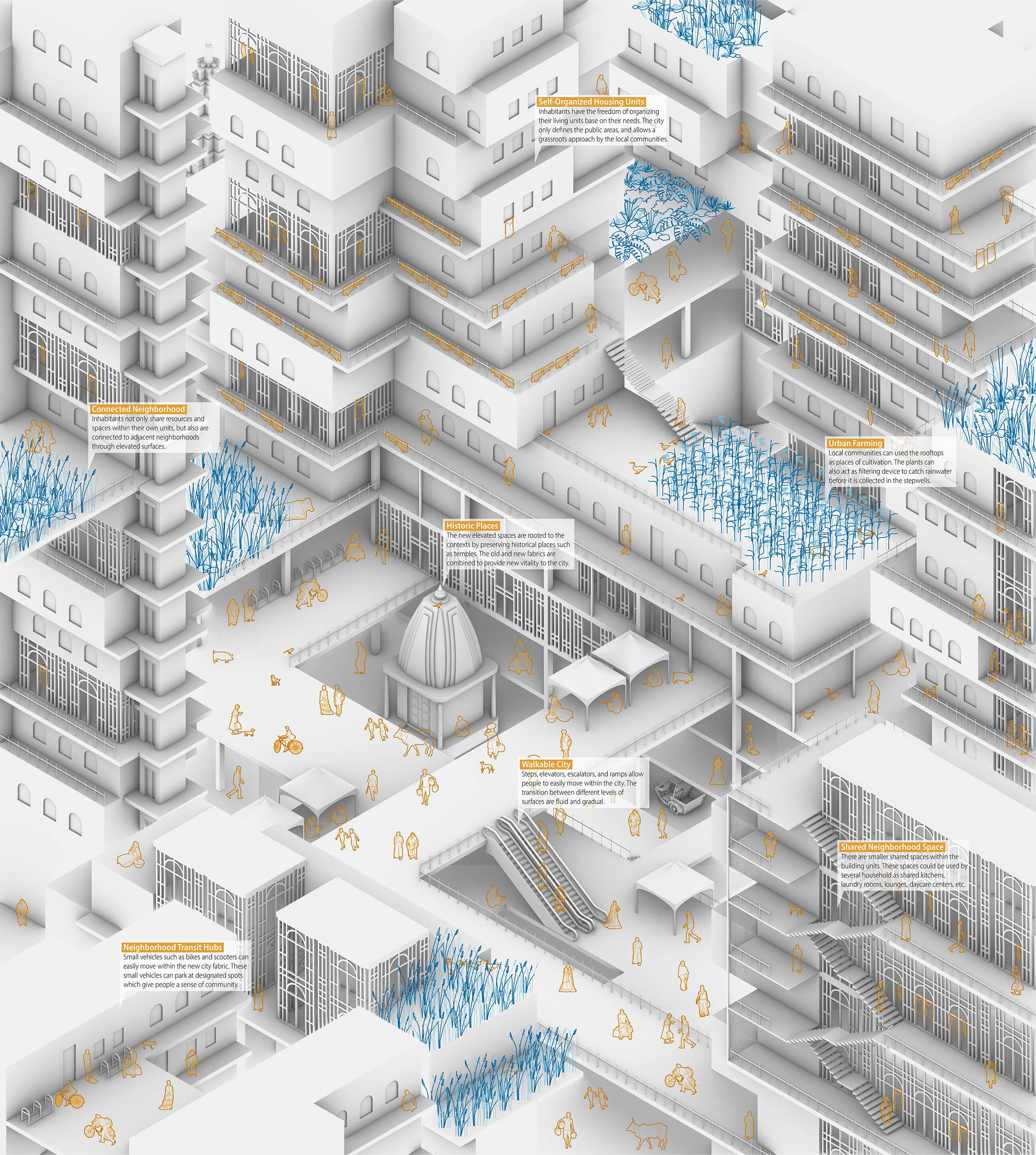
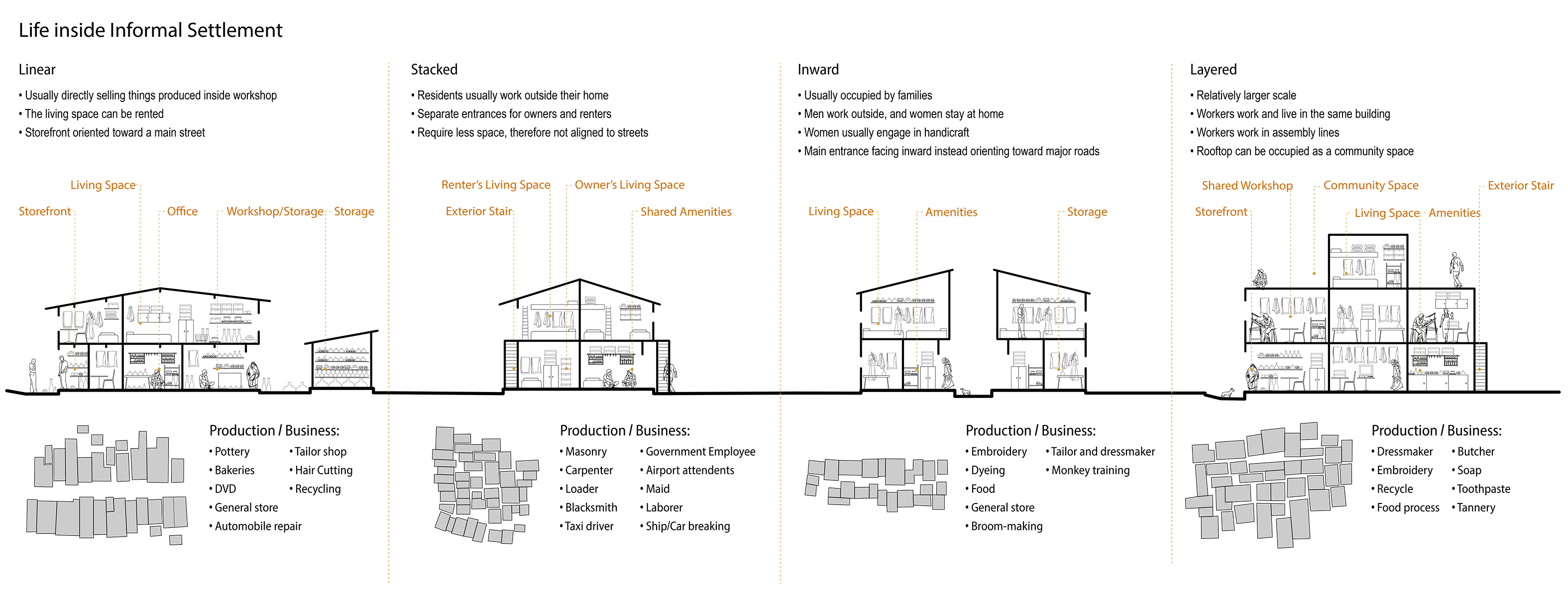
Life Inside Informal Settlement
It is inappropriate to call informal settlements in Mumbai “slums“, because the word cannot capture the incredible vitality and complexity inside of these spaces. Almost ever inch of the spaces is mixed-used and sharing is a prevalent idea. The construction of informal settlements shows the ability of self-organization of people in Mumbai and indicates potential for a grassroots approach in our design.
It is inappropriate to call informal settlements in Mumbai “slums“, because the word cannot capture the incredible vitality and complexity inside of these spaces. Almost ever inch of the spaces is mixed-used and sharing is a prevalent idea. The construction of informal settlements shows the ability of self-organization of people in Mumbai and indicates potential for a grassroots approach in our design.

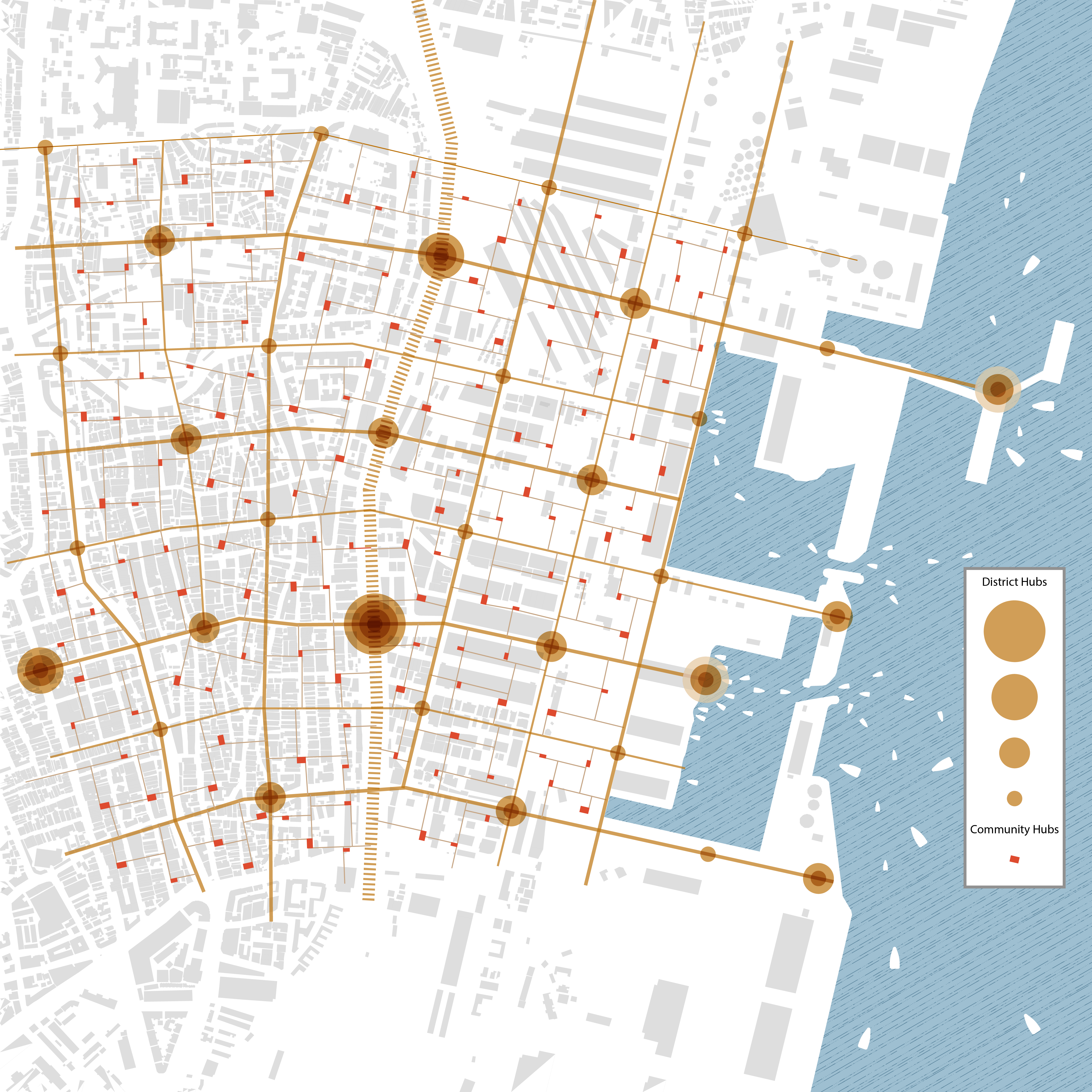
Mumbai New Mobility System and Community Hub
Base on the current location of train stations and streets, the proposed system will increase the connectivity between east and west Mumbai Metropolitan Region by adding a new network of multimodal transportations. Light rails, rickshaws, motorbike, and bikes could all function within the network and relieve the pressure of the train. The stations evenly distribute in the Mumbai Metropolitan Region allowing people to choose the best suited vehicles base on their needs. The stations could also function as community centers which gather people and allow a variety of activities to happen.
![]()
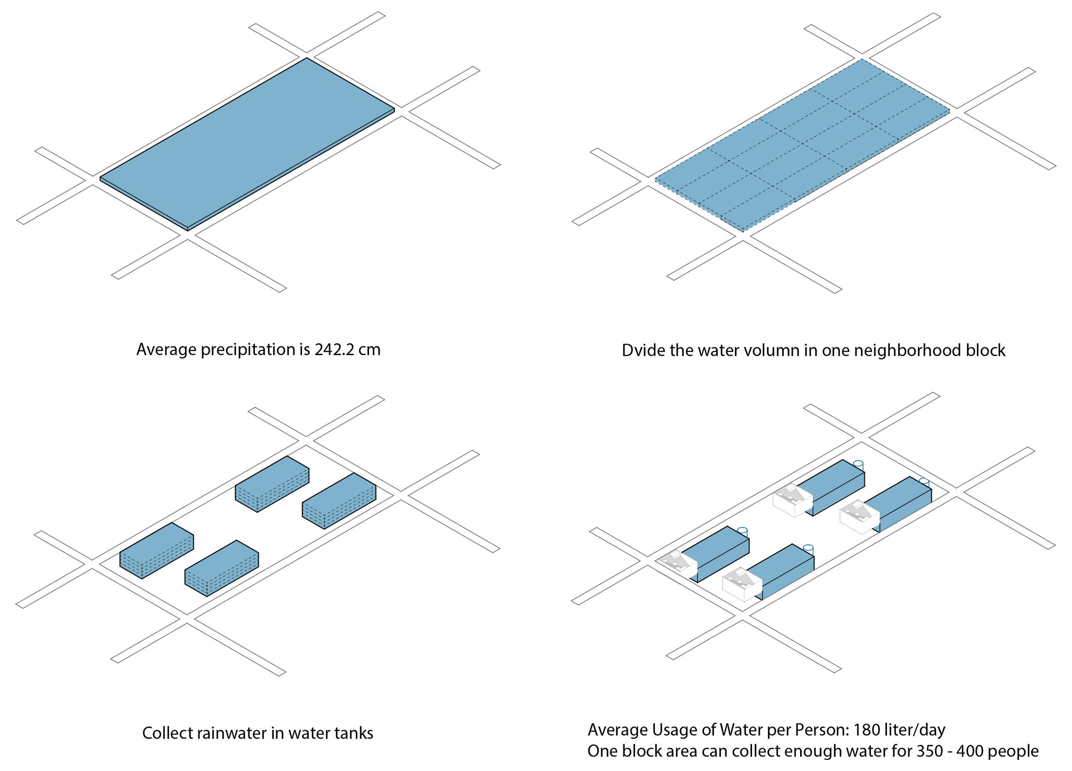
Mumbai New Watershed
During monsoon season, the stations will be able to harvest and manage rainwater through a system of water storage tanks. The harvested water will be filtered and cleaned on site and used by the adjacent communities. The annual precipitation in Mumbai is about 2.5 meters. Given the size of land, if the rainwater is collected, it will be a incredible resource to relieve the water shortage. Based on our analysis, the proposed stations on the Eastern Waterfront will be able to manage almost half of Mumbai’s watershed.
Base on the current location of train stations and streets, the proposed system will increase the connectivity between east and west Mumbai Metropolitan Region by adding a new network of multimodal transportations. Light rails, rickshaws, motorbike, and bikes could all function within the network and relieve the pressure of the train. The stations evenly distribute in the Mumbai Metropolitan Region allowing people to choose the best suited vehicles base on their needs. The stations could also function as community centers which gather people and allow a variety of activities to happen.

Mumbai New Watershed
During monsoon season, the stations will be able to harvest and manage rainwater through a system of water storage tanks. The harvested water will be filtered and cleaned on site and used by the adjacent communities. The annual precipitation in Mumbai is about 2.5 meters. Given the size of land, if the rainwater is collected, it will be a incredible resource to relieve the water shortage. Based on our analysis, the proposed stations on the Eastern Waterfront will be able to manage almost half of Mumbai’s watershed.


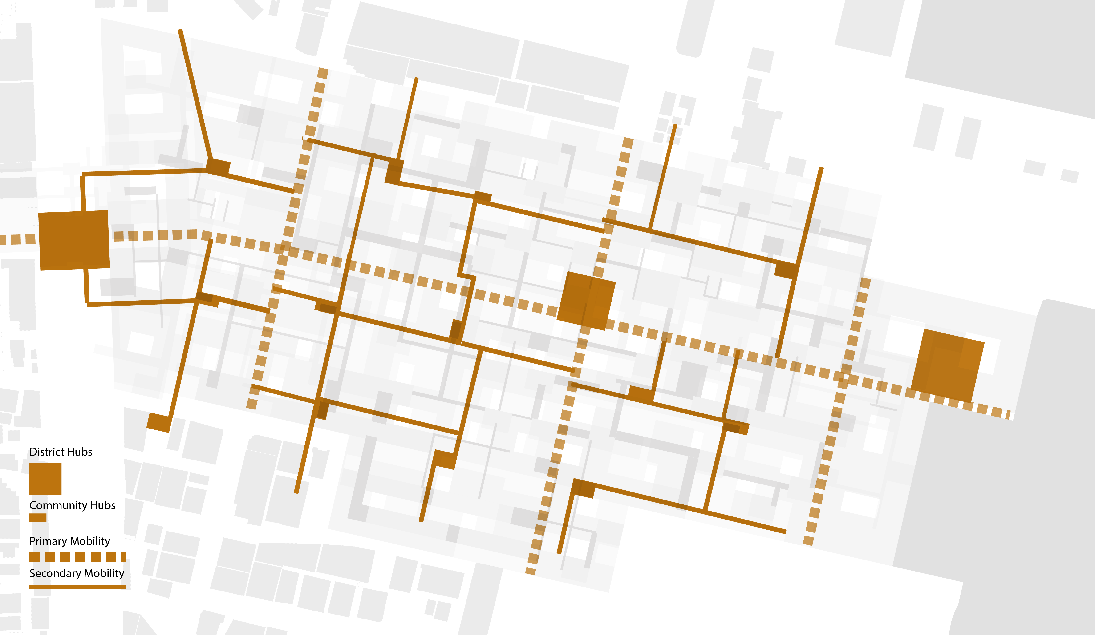
Replicability of the Site Design
In our proposal, we made an intentional decision to not take over the entire given site. We would like to suggest that the design is replicatable through out the entire Eastern Waterfront of Mumbai.
The connectivity of our design is not limited in one place, but can be part of a bigger network of the city. The inherent principle of our proposal allows it to grow over time, and adapt to any changes which might happen in the region. We would like to empower the inhabitants to make decisions about their environment and take responsibilities of their home. Each place might look different, but the principles are the same across the Eastern Waterfront - defined public space, self-organized settlement, mixed-used programs, mutimodal transportations, etc.
Site
Our proposal currently only takes about half of the given site on the Eastern Waterfront. The proposed district hubs and community hubs are based on the location of existing buildings which have historic or emotion values to the communities. On the one hand, these hubs are already gathering place for people; on the other hand, though the development of the site is new, the spirit of the place is preserved through these existing structures.
The scale of the hubs are different across the site, and they support different transportations which operate at different level - urban, district, and local. Starting with these hubs, the network of mobility can gradually grow into a complete network which allows free movement of both people and water.
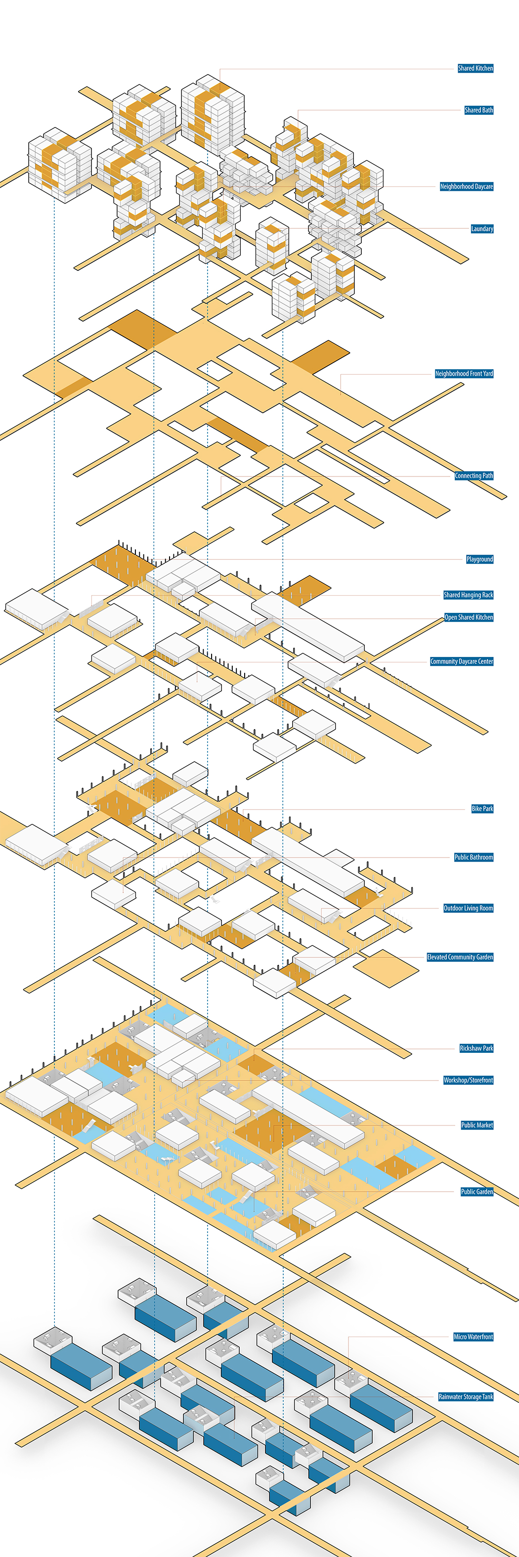
The site strategy is a pilot design which could be adapted to other parts of the Eastern Waterfront. The design expands the existing train station on our site and extends it into the water. We created a system of water tanks and steps to collect water. There are also a few principles to organizing the shared surfaces. North light is preferred in India because of the hot climate, so we ensured all the private homes are facing north and the water tank with steps are places in northside to give enough space for light. The lower levels are more public and open to allow free movement, different type of public life could happen here. And more private spaces are located above with smaller shared spaces weaving them together.
In our proposal, we made an intentional decision to not take over the entire given site. We would like to suggest that the design is replicatable through out the entire Eastern Waterfront of Mumbai.
The connectivity of our design is not limited in one place, but can be part of a bigger network of the city. The inherent principle of our proposal allows it to grow over time, and adapt to any changes which might happen in the region. We would like to empower the inhabitants to make decisions about their environment and take responsibilities of their home. Each place might look different, but the principles are the same across the Eastern Waterfront - defined public space, self-organized settlement, mixed-used programs, mutimodal transportations, etc.
Site
Our proposal currently only takes about half of the given site on the Eastern Waterfront. The proposed district hubs and community hubs are based on the location of existing buildings which have historic or emotion values to the communities. On the one hand, these hubs are already gathering place for people; on the other hand, though the development of the site is new, the spirit of the place is preserved through these existing structures.
The scale of the hubs are different across the site, and they support different transportations which operate at different level - urban, district, and local. Starting with these hubs, the network of mobility can gradually grow into a complete network which allows free movement of both people and water.
The site strategy is a pilot design which could be adapted to other parts of the Eastern Waterfront. The design expands the existing train station on our site and extends it into the water. We created a system of water tanks and steps to collect water. There are also a few principles to organizing the shared surfaces. North light is preferred in India because of the hot climate, so we ensured all the private homes are facing north and the water tank with steps are places in northside to give enough space for light. The lower levels are more public and open to allow free movement, different type of public life could happen here. And more private spaces are located above with smaller shared spaces weaving them together.


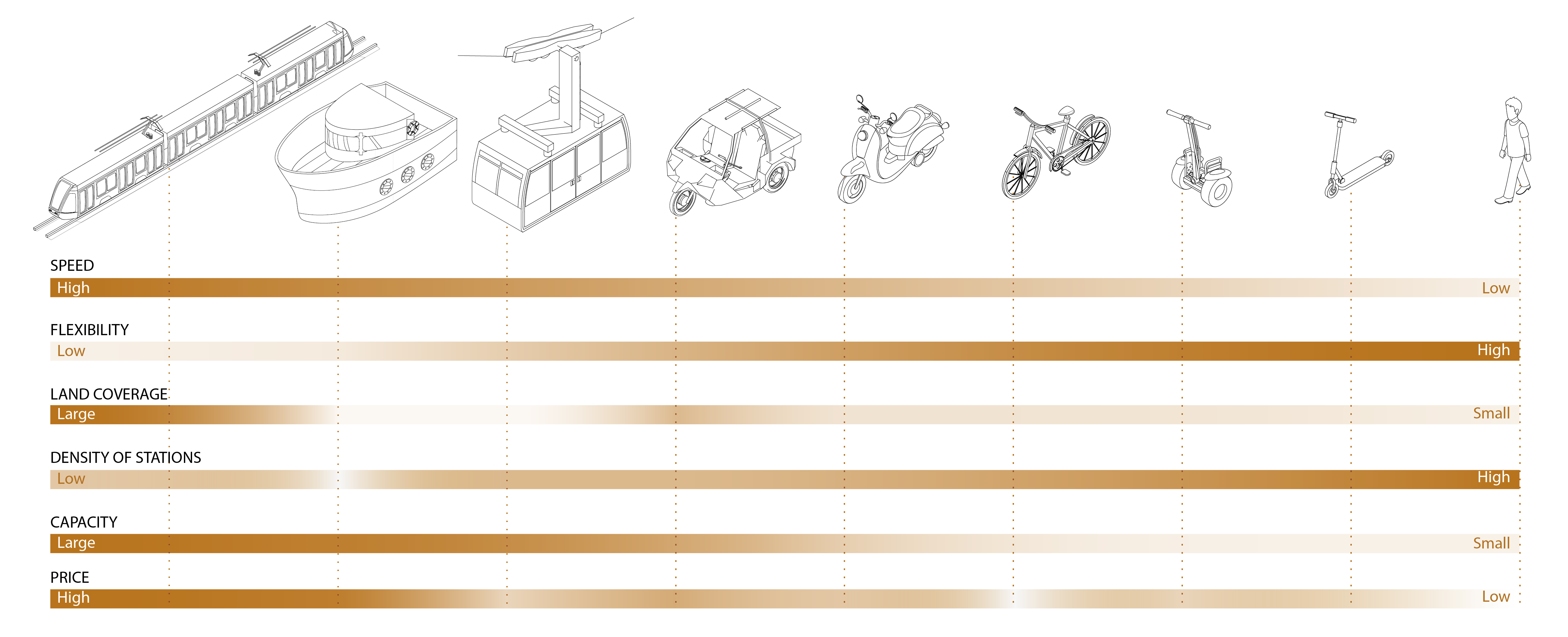
Mobility Hubs
These hubs consist of bikes and rickshaws parkings, public transportation stations. The connection between each hubs are at different levels base on the speed of human movement. The railways are the fastest and can carry the largest amount of people, so these stations are at the ground level. Cars can also occupy the ground level, but with multiple other mode of transportation such as bike and rickshaws, cars are no longer the dominant mode of transportation.
Water Hubs
There are multiple stepwells on the site which can collect and filter rain water during the monsoon season. These stepwells can store water underground and pump water upwards through pipes connected in every household. During dry season, the steps are public spaces which provide shade in the hot climate of Mumbai.
Public Spaces
Public spaces are at multiple levels and can be used for different activities - outdoor kitchen, public market, shared community gardens, urban farms, etc. The perforated levels create courtyards at different levels and allows light to come through. These shared surfaces also provide visual connections for people in different neighborhoods.
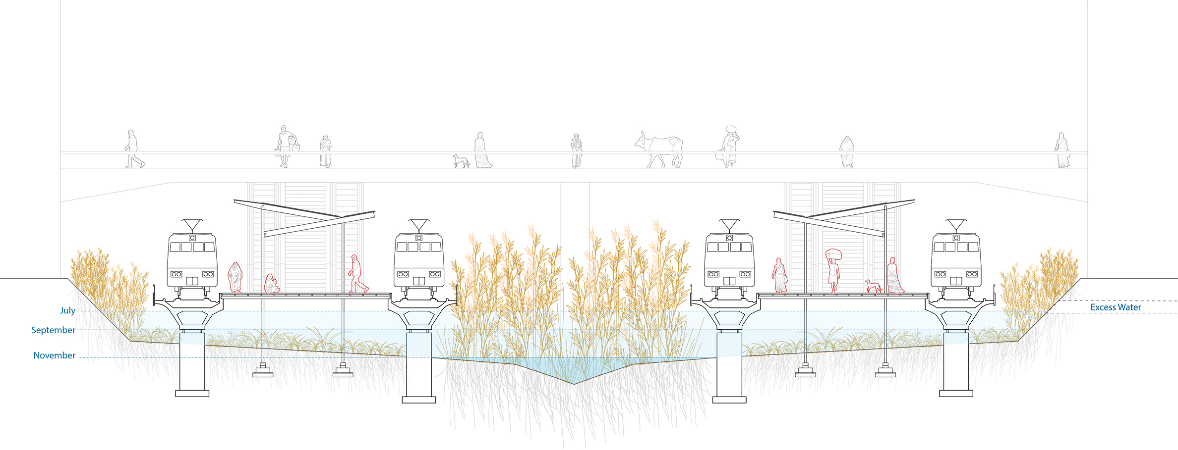

Elevated Railway Track
The movement of water is an important part of our proposal. The railway tracks are elevated to allow water to stay on site while ensure the normal operation
of the train. The excess rainwater during monsoon are released through pipes into the ocean.
Through out the entire site, water stay and move at different speed and different level, and therefore creates a dynatic space for people and other species.
Through out the entire site, water stay and move at different speed and different level, and therefore creates a dynatic space for people and other species.